What's A Barrier Island?

What's a Barrier Island?

Barrier Islands LandSat
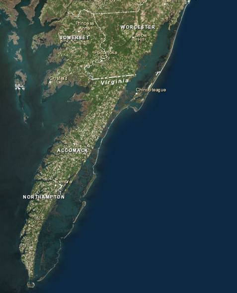
Eastern Shore Virginia via Nasa LandSat
Barrier Islands can be seen off the mainland.


Northampton County's barrier islands are among its most important and unique natural resources. For centuries, they played a major role in the history, economy, and culture of the area. Although there once were small fishing villages and hunting lodges on the islands, today they are uninhabited. Most of the islands are included in the Virginia Coast Reserve, which is an island and salt marsh preserve owned by The Nature Conservancy of Arlington, Virginia. The Virginia Coast Reserve has been designated an International Biosphere Reserve by the United Nations in recognition of the importance and fragility of the ecosystem. Northampton County's islands, together with contiguous islands in neighboring Accomack County, represent the last undeveloped barrier island system on the Atlantic Coast.

There are twelve barrier islands in Northampton County. Hog, Rogue, Cobb, Little Cobb, Ship Shoal, Godwin, Myrtle, Mink, and Smith Islands are mostly owned by The Nature Conservancy. Northampton County Barrier Islands
The Commonwealth of Virginia owns Mockhorn and Wreck Islands. Fisherman’s Island, on the tip of the peninsula, is owned by the Federal government and is part of the Eastern Shore National Wildlife Refuge. The Nature Conservancy has specific rules regarding the use of the islands they own. Most of the islands are open to the public for low-impact, non-commercial, recreational day use (hiking, bird watching and fishing). Motorized vehicles, pets, and overnight camping activities are prohibited. There are also seasonal restrictions to protect nesting birds.

The barrier islands play a number of important roles in Northampton County including: protection from storms as buffers to dissipate the energy of the ocean; economic benefits including commercial and recreational fishing; recreation including fishing, hunting, crabbing, clamming, hiking, boating, and bird watching; and nature study as an educational resource, increasing awareness of the importance and rarity of the island system, and protection of threatened species, offering sanctuary to many species of birds, mammals, and reptiles that are threatened or endangered.

The islands are dynamic in nature; migrating westward over the past 160 years. Because the Virginia Coast Reserve is gaining national and international attention as one of America's last remaining intact barrier island systems, Northampton County benefits through research and educational programs centered around the island system. The University of Virginia has established a National Science Foundation Long Term Ecological Research Center in Northampton County and established its headquarters in the Village of Oyster. Most of the barrier islands are included either in the Virginia Coast Reserve, the Federal National Wildlife System, or the Virginia Natural Areas Program, but even limited development on any of the islands would drastically alter the system scientifically and aesthetically.

In managing the barrier island system, biological diversity has been the priority. It is important to recognize that the island system functions as an interdependent whole. The system includes related natural communities of beaches, dunes, upland forest, extensive salt marshes, bays, creeks, guts, unvegetated wetlands, mainland salt marshes, and any seaside mainland which is part of the watershed.

Source: Northampton County Comprehensive Plan Part II Chapter 4,5,6 Revisions per 9-5-18 meeting


IF YOU GO: 

Check out the Explore Our Seaside website.

The Nature Conservancy manages the barrier islands off the coast of the Eastern Shore of Virginia and is known as the Virginia Coast Reserve.

Sandpiper forages in the tide line. "The barrier islands shelter more than 250 species of raptors, songbirds, and shorebirds, which find food in the adjacent bays and salt marshes. "
https://www.nature.org/en-us/get-involved/how-to-help/places-we-protect/vcr-barrier-islands/

It is very important if you are visiting the islands to be respectful of the protected wildlife and the fragile habitat. 

Most Conservancy owned islands are open to the public for low-impact, non-commercial, recreational day use, such as hiking, bird watching, surf fishing and photography.

Please note: Dogs are not allowed on the Virginia Coast Reserve barrier islands due to the nesting birds who lay their eggs in the sand and dunes. 

"People using the beaches during the breeding season present an additional challenge to beach nesting birds and may unknowingly impact the birds’ chances of success. Someone wandering through a nesting area may accidentally step on well camouflaged eggs or chicks. Dogs can quickly find and destroy nests or chase young birds. Additionally, people and pets venturing too close to nesting sites cause adult birds to leave their nests, exposing chicks and eggs to predators or excessive temperatures. Trash left in nesting areas attracts raccoons and gulls, and places the birds in greater danger of being discovered by predators." 
-From the Virginia Barrier Islands Beach Nesting Birds Brochure

PETS, MOTORIZED VEHICLES,
CAMPING AND CAMPFIRES ARE
PROHIBITED AT ALL TIMES


Hours: Daily ½ hour before sunrise to ½ hour after sunset.

For more details on the visitation policy, seasonal restrictions and other important information to know before you go please visit:
Virginia Coast Reserve Barrier Islands website. 


The Shifting Sands of the Barrier Islands

In the video below, Captain Rick Kellam of Broadwater Bay Ecotours speaks to The Virginian Pilot about the changing Barrier Islands of the Eastern Shore. Captain Kellam is "a guide, naturalist, author, historian, and descendant of the inhabitants of these extraordinary islands." 

Read the full article Some Virginia barrier islands are shrinking by the day: "You can just feel it" by Dave Mayfield and published in The Virginian-Pilot on March 2, 2017


Tide and Time Wait for No Man

Houses on Cedar Island wash away into the sea.


The Barrier Islands are constantly transformed by wind and waves and shifting sands.  They are a great place for a day trip but are not a stable place to put a home.

Read about "The Last House on Cedar Island Slips into the Sea,"  and how a plan to make the Barrier Islands into the next Ocean City was foiled. "The Last House on Cedar Island Slips into the Sea," was written by Rona Kobell and published in Bay Journal on December 2, 2014. 


These houses on Cedar Island were built on solid ground until the shifting sands and tide claimed them. Source: usgs.gov


 Another interesting resource about the geology of the barrier islands and the changes over time can be found at http://www.virginiaplaces.org/geology/barrier.html. 
 See the Fisherman's Island morph over time with the 
Google Earth Engine Timelapse

Fisherman's Island off the Southern Tip of the Eastern Shore can be seen in this aerial photo along with CAPE CHARLES, ADAMS ISLAND, SMITH ISLAND, MYRTLE ISLAND, SHIP SHOAL ISLAND, WRECK ISLAND, MOCKHORN ISLAND, and the CHESAPEAKE BAY. Source: nasa.gov Gateway to Astronaut Photography of Earth taken by the ISSO. Photo ID #ISS059-E-18883 


Watermen head in from the Barrier Islands
Watermen head in from the Barrier Islands toward Oyster Harbor. 
Photo credit: Richard Wiseman